OR - Greater Allegany Passage (GAP) Trail
Traveling east from Pittsburgh, the termination of the GAP trail is in Cumberland. It is 148 miles in length. If traveling onto Washington (i.e. Georgetown) along the C&O Towpath (185 miles), Cumberland is roughly the midpoint of the trip. Cumberland is important either as the terminus or midpoint.
CUMBERLAND TIMES-NEWS COMMENTARIES:
I have authored a series of commentaries in the Cumberland Times-News. These commentaries focus on developing outdoor recreation opportunities in Cumberland, Maryland. The commentaries tend to focus on developing a whitewater park and the GAP trail. More recently, they have begun to focus on climbing opportunities in the Narrows. The commentaries on the GAP trail are contained on that site.
COMMENTARIES:
Climbing could be our new industry
May 25, 2016, p. 4-A
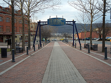
Cumberland Terminus - The beginning or terminus of the GAP trail (Mile 0).
Two down, one to go for Allegany Highlands Trail
Friday, August 26, 2005, page 4B
Proposed rail-trail would benefit community, landowners
Monday, November 22, 2004, page 8A
Area losing money each year bike trail is not completed.
June 13, 2004, page A4
Sometimes you have to go somewhere else to learn what you need to do at home.
November, 2003

UMPC and Pittsburgh - The GAP trail weaves its way into downtown Pittsburgh. The University of Pittsburgh Medical Center (UPMC) is in the background.
PHOTO GALLERY - Along the Trail:
The photo gallery contains photos taken along the trail. They are a sampling of all my photos. The trail is broken into the following segments. Click on the section and go directly to that section.
Sample photo for Miles 0-24: Cumberland to Deal
This section includes the Mt. Savage Tunne - see below.
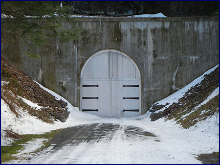
Mt. Savage Tunnel - Winter with the Doors Closed.
Sample Photos Miles 24-36: Deal to Garrett
This section includes the Keystone Viaduct, and Meyersdale Viaducts. See sample images.

Rock Slide - The trail requires maintenance and this rock slide near the Keystone Viaduct requires removal.
Bridge Raising - Preparing for the bridge raising, Keystone Viaduct.
Sample Photos Miles 36-80: Garrett to Connellsville
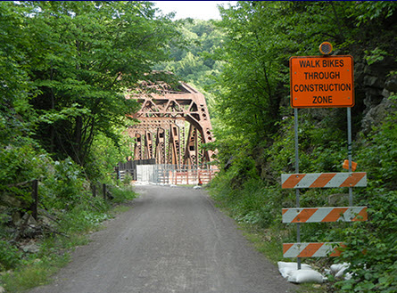
This section includes Pinkerton Tunnel and bridges and Ohiopyle. See sample images.

High Bridge at Pinkerton - Biker views westward. The tunnel is behind the biker.

Disadvantaged Cross Lower Pinkerton Bridge - Two disadvantaged power their way across the lower Pinkerton Bridge. Don't be surprised that disadvantaged will use the trail. Why not, the trail which is perfectly suitable for a bike is also suitable for a power chairs.
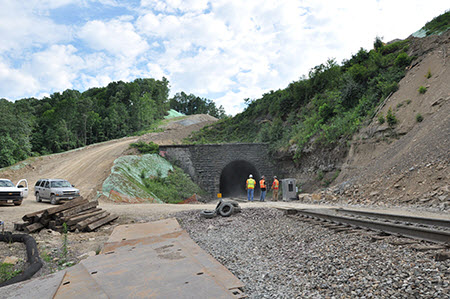
Sample Photos Miles 51: Pinkerton Tunnel Removal
The Pinkerton Tunnel removal by CSX is on its own page. The Pinkerton Tunnel on the GAP Trail is on the Garrett to Connellsville section. See sample images.
4-wheeler Uses New Track - A 4-wheeler takes advantage of the new track. 10/21/2012.

Pinkerton Tunnel Removal - Looking east, a train uses the temporary track as tunnel is demolished. 5/14/13.
Sample Photos Miles 80-148: Connellsville to Pittsburgh
This section includes Connelsville, West Newton and everything west to Pittsburgh.

Along the Trail - Bikers pedaling along the tree lined trail.

Bikers Along the Trail - Blythedale, near Buena Vista.